
railway-international.com
01
'26
Written on Modified on
Rail Baltica uses GIS digital twin to unify infrastructure data
Esri-based platform enables real-time project visibility and faster defect detection across multi-country railway project.
www.esri.com
The Rail Baltica is a large-scale greenfield railway initiative connecting Estonia, Latvia and Lithuania to the wider European rail network. Spanning 870 km, the project includes not only tracks but also signalling systems, utilities, communications networks and stations.
Given its scale, the project involves hundreds of contractors generating large volumes of data daily. However, this data was often stored in separate systems with inconsistent collection and exchange practices, leading to duplication and limited visibility across teams.
The lack of structure made it difficult to track available information or ensure that collected data was effectively reused.
Implementing a GIS-based digital twin
To address these challenges, Rail Baltica implemented a geospatial digital twin based on Esri technology. The platform consolidates data from multiple sources into a single, structured environment representing the entire infrastructure.
The GIS system defines clear workflows for how data is collected, stored and accessed. This ensures that information is standardized and available to all stakeholders, reducing fragmentation and improving collaboration.
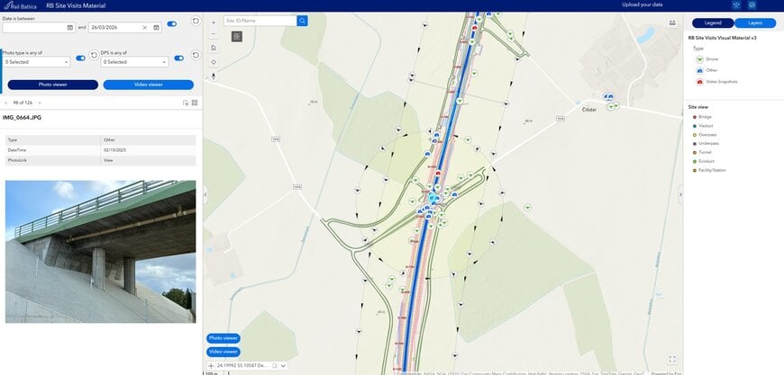
The digital twin integrates inputs such as photos, videos, drone footage and satellite imagery, enabling a comprehensive and continuously updated view of construction progress.
Improving monitoring and decision-making
A key requirement was efficient monitoring of construction activities across multiple sites. Among various data sources, photo and video documentation proved particularly effective due to ease of use and rapid availability.
Construction teams can now review site progress remotely, reducing the need for frequent on-site visits. The system also allows users to track changes over time at specific locations, supporting better oversight and coordination.
The centralized platform has also revealed previously unused data, increasing overall data utilization and reducing redundant data collection efforts.
Early defect detection through accessible data
The benefits of the GIS approach were demonstrated when weekly construction videos revealed incorrectly installed barriers months before the issue was formally identified through LiDAR scanning.
While LiDAR data required longer acquisition and processing times, video data was available within days, enabling earlier detection of potential issues.
This highlighted the importance of both timely data availability and ensuring that relevant stakeholders actively review the information.
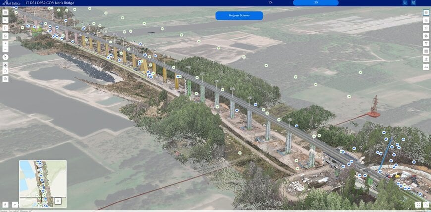
Railway viaduct supervision © Esri
From data collection to digital sustainability
Rail Baltica has introduced the concept of “digital sustainability,” aiming to ensure that once data is collected, it is preserved and remains usable throughout the project lifecycle.
Data collection now follows two streams: structured contractor submissions and targeted data captured by in-house specialists during site visits. This combination improves both coverage and relevance of the data.
Training initiatives are also being implemented to improve metadata quality and encourage consistent data usage across teams.
Building a long-term asset data foundation
The GIS platform is evolving into a comprehensive asset register that connects design, construction and future operations. Data collected during early project phases is reused to validate construction progress and identify discrepancies.
This continuity reduces data loss between project stages and supports long-term infrastructure management.
Measurable impact on project efficiency
The implementation of the digital twin has reduced the time required to access, collect and share data, enabling faster decision-making across the project.
By centralizing information and improving visibility, Rail Baltica has created a scalable digital foundation that supports both current construction activities and future operational needs.
The case demonstrates how GIS-based digital twins can transform data management in large infrastructure projects, improving efficiency, reducing redundancy and enabling earlier identification of issues.
Edited with AI assistance.
www.esri.com